Friday, April 25, 2008

It's about time!

So why do I have a photo of a pile of crap posted in this blog? It's because that pile of tents, sleeping bags, gear bags, sleeping pads, etc. is our camping gear waiting to be loaded into our CR-V tomorrow morning for the first "waycamping" trip of the season! Finally the weather has cooperated and there will be high temperatures in the balmy lower to mid 60's on both Saturday and Sunday! The night temperatures will be around 45 degrees which is a bit chilly for tent camping, but we've camped in worse (try 35 degrees in a rainy windstorm). Also, we have two little dogs who love to sleep at the bottom of sleeping bags and they make awesome foot warmers.

So the camera and gps batteries are fully charged, the maps are printed and we are SO ready to hop on the ferry and get this weekend rolling. I've printed out the National Park's driving tour (we're camping at a fort within Ebey's Landing National Historical Preserve) and have extra flashlights packed for exploring the military batteries at the two forts (Fort Ebey and Fort Casey). This particular preserve is actually the first National Historical Preserve in the United States, created in 1978. It's different than a National Park or National Monument in that the land within the preserve is all privately owned. The area is a pristine example of early settlement in the islands of the Puget Sound. By the 1970's the area was still not much different than it had looked in the early 1800's when it was settled. Many of the early homes, businesses, barns, farmlands still existed. So the National Park Service purchased the development rights from the owners of the properties within the reserve. Then a locally elected management group was set up to maintain the preserve. The farmers can still farm their land, people live in the old homes, and the old buildings of early Coupeville (a historic town within the preserve) are still filled with small businesses. However, now there are mandates in place that limit development within the residential and business areas and the farms cannot be subdivided and turned into new housing developments. The two WWII era forts within the preserve are run as state parks. It's a wonderful park unit within the state of Washington that very few people know about.

So, I'll report back on Monday to share the adventure.

Tuesday, April 22, 2008

New Categories

I have to say I'm a bit shocked. Usually when I go to the category review page and see over 4 different categories to vote on almost every one of them is by a new waymarker that has gotten overly excited and doesn't quite understand what creating a category entails.

I feel a bit bad for them, but often, it's "nea" down the list of them with pretty much the same explanation: "You need to take more time writing up the category. The long description is an important part of the category, because it helps people understand what is being looked for - it can't be skipped. Also, you need to think through some posting requirements so, again, people know what you are looking for - we can't read minds." Yada yada yada....

Today when I opened the voting page and saw 5 categories that I needed to vote on I thought, "oh man - not again!" Boy was I surprised as I read the categories and they all seemed to be well thought out and written. The "Water Parks" category needed a bit of work, but it still worked. At first I thought the "Historic Houses" would deserve a no vote for being too broad, but as I read through their detailed description I better understood the category. Although I think a better name would be "Historic Houses: Pre-Victorian" so they don't get a bunch of Victorian houses submitted by folks that don't stop to read the category description and requirements before they post.

It felt good to be able to vote yes for a change.

Saturday, April 19, 2008

Postponing the Crazies

Okay, I'm sitting here gazing out the window and snowflakes are softly falling from the sky, drifting past the blossoming cherry tree and the bright yellow daffodils in my back yard, Bach's cello 1st cello suite plays endlessly in the background (not because I have a CD in but because my son is practicing cello) and I once again curse the weather. If you've never heard Bach's 1st cello suite you really should - it is the essence of melancholy and is the perfect soundtrack for this tableau of suburban sorrow.

I will not be camping this weekend. When I took the dogs out last night to fertilize the lawn I realized that crazy or not I would be miserable sleeping outside in this weather. Earlier in the evening I had actually begged my awestruck husband (I'm always bitching about being cold) to camp out on the windy and snowy bluffs of Whidbey Island and called him a wimp for not being willing to consider it. But last night in the snow with the dog crap steaming in a pile of snow at my feet, I finally accepted my lot. The weekend trip to the island would have to be postponed. All that planning - the lists, the maps, the perfect campsite, the printed out driving and walking tours - now sit in a forlorn pile on the coffee table.
So now we are hoping to camp next weekend, our last open weekend before school gets out and we fly to the east coast. I might actually crack if we have another sunny week that ends in snow and rain. I NEED a day of blue skies. Even just one day would do me, but I swear I'll go psychotic if I don't get out for some camping and hiking soon.

A last minute day trip has been planned, a sad replacement for the weekend I had planned, but it will still be fun if I can let go of the bitterness. We'll be driving down to Centralia, Washington (named for its location halway between Seattle and Portland) and then taking Old Highway 99 north, visit a sculpture park along the way, and end up in Olympia for a late lunch at the Spar Cafe, maybe some time at the Olympia Farmers Market, and a quick stop at Wagner's European Bakery for some goodies to eat tonight while we watch a movie. We'll be hitting a couple roadside attractions along the way, some beautiful old historic architecture, and waymarking some great vintage neon which I'm sure will console me a bit.
The photo above was taken last weekend at Point Defiance Park in Tacoma. It is an example of Western Washingtonians thinking that the blueish tint to the overcast sky is actually sunshine and heading to the beach. You see, it's been so long since we've seen true sunlight that we forget what it looks like. Of course they are still wearing Goretex ski coats. Any Washingtonian worthy of the title knows that you can't put away your Goretex until the 4th of July.

Thursday, April 17, 2008

Spring Craziness

Every spring, usually in early April and sometimes even as early as March, I start to get an itch to get out of town and go camping. It's like the stuffy air of a fall/winter spent inside starts to get me a little nutty and I crave fresh air and forests. The problem is that the damp season here in Western Washington lasts from about September through the end of June. I mean, we get some beautiful days during that time, don't get me wrong, but the chance of those beautiful days falling over a weekend are rare until late June. The photo below, taken from Deception Pass at the north end of Whidbey Island, was taken over just such a weekend - a glorious sunny stretch in October a couple of years ago.


Well a couple of weeks back I decided I couldn't take it any longer and planned a weekend trip to Whidbey Island for this coming weekend. I crossed my fingers and hoped that the stars would aline and we would get a beautiful weekend.

Well, as that began to look increasingly unlikely I figured we could stay in a hotel and just spend the days outside. No such luck - a couple with a fourteen year old teen and two dogs are about as welcome to hotel managers as a couple of lepers. Anyhooo - so the weekend is supposed to be off. But now I'm totally invested. I mean - this place is a waymarking paradise: central Whidbey Island is a National Historic Reserve co-managed by the National Park Service and a group of locally elected officials. It has been kept much as it looked in the late 1800's with wide open prairies, windswept bluffs and beaches, a small town with most of its architecture from the 1800's, and not 1 but two forts that have been turned into state parks with a ton of batteries to explore. The entire reserve is listed on the National Register of Historic Places as a historic district. I've downloaded walking and driving tours, trail maps and read up on the history. I have a list of good restaurants and cafes. This is killing me!!!! I must escape this suburban hell!!!

So now the question is do we stay home and take a day trip on Saturday down to Olympia or do we brave the cold (and possible snow) and head to the island anyway. Mind you, we are pretty hardcore campers so when I say "camping" I mean a three person backpacking tent in a walk-in campsite, not a motorhome with a heater, toilet and microwave. The predicted weather is highs in the mid to upper 40's and lows from the lower to mid 30's. At this point there's about a 30% chance of precipitation and the snow level is down to sea level, but central Whidbey is in the Olympic Mountains' rain shadow. How bad could it be? I don't mind cold weather camping, but I don't handle wet and cold camping well (which is why I hate snow camping.)

Our 14 year old is game, but this is a kid who wears shorts year round. Hmmm... well, stay tuned to hear if decide to embark on this mad adventure.


The photo above was taken during a past season of madness. We were backpacking in the Cascades up off of highway 2 and when we hit the last 1/2 mile we discovered that the trail (and our campsite) would be in snow. This did not stop the guys from swimming in the pristine glacial lake - or me from laughing at them after they hit the water and tried to scramble back out before their muscles seized up from the cold.

Monday, April 14, 2008

On the road again.... (I wish)

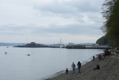
Well, we're not on the road yet, but I'm definitely itching to see the Tacoma area in my rearview mirror. Team Hikenutty absolutely LOVES road trips of all lengths, which makes us a big fan of the highway categories. So far the Website has categories for the Mother Road (US66), the National Road (US40), the Dixie Highway, the Pacific Highway (US99) and for Lincoln Highway Markers. I WANT MORE!!!

You'd think that those five would be enough, but recently I bought a couple of books that have me thinking of other great highways that could use a category.

First, I think that the Lincoln Highway could use a second category that is wider reaching. Currently only highway markers can be waymarked along that route, but last summer while traveling along the Lincoln we saw some awesome spots. Old service stations, vintage motels, roadhouses that have been open since the 1920's, road camps, and more. These places deserve their own category! I'm fine with the current category keeping its focus on the roadside markers, but I think there is some great Americana along the route that should be grouped together in its own category.


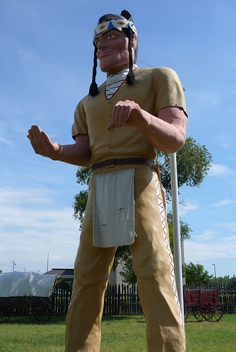
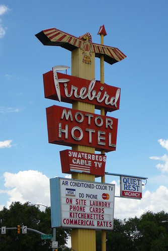
(L) Muffler Man in North Platte, NE; (R) Old Lincoln Hwy. motel in Cheyenne, WY


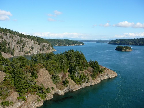
One more category and we should have the major east/west highways covered. We have the center of the country covered, but what about up north? Highway 2, dubbed the Great Northern, is the longest of all of the great transcontinental road trips in the U.S. and also the most stunning of the east/west passages. It takes you over the Cascade Mountain Range and past the Grand Coulee Dam in Washington, over the Rocky's and through Glacier National Park, the North Woods of Minnesota, Michigan's Upper Peninsula, into Canada, over Vermont's Green Mountains, through New Hampshire's White Mountains and ends up in Maine's beautiful Acadia National Park. Along the way you'll experience gorgeous spots and plenty of vintage Americana. I've never really travelled this route however I have been to Grand Coulee Dam country and here are a couple photos of that area.


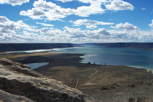
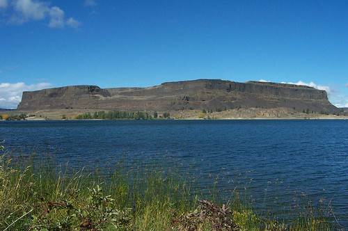
(L)Banks Lake, a Grand Coulee reservoir, seen from atop Steamboat Rock; (R) Steamboat Rock


Now that we have the east/west covered, I'll move on to the north/south corridors. So far the only full, cross-country north/south route that has a category is the Pacific Highway, US 99, which confusingly doesn't get near the Pacific Ocean. I propose four more - yep four - north/south routes that are all truly exquisite road trips.

First (and nearest and dearest to my heart) is the Pacific Coast Highway, US101. This is completely different than US99 (which is full of Americana, but very light on scenery). Many consider it to be the most beautiful long distance road trip you can take in the U.S. and I would definitely agree with them. Sorry to all of you easterners out there but there isn't much that can beat US101's views of the Pacific. You'll start up north in one of my favorite stomping grounds, Olympic National Park and from there you'll head south, hugging the coast. See the beautiful Hoh Rainforest in Washington, the many peaceful, pristine beaches of Oregon, Redwood National Park and Big Sur in California. And as many of you know, kitsch can only reach its full potential in beach towns for some reason. Maybe it's the salty air. I've travelled 101 from it's beginning in Olympic National Park down to San Francisco and the roadside attractions just can't be beat. These places should be gathered together in a Coast Highway category and I'd be willing to lead it if anyone is interested.


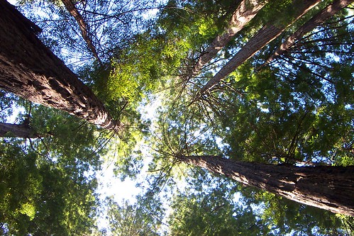
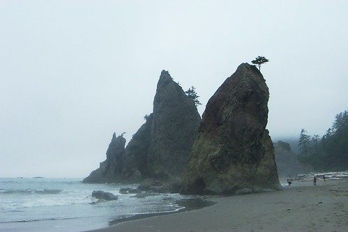
(L) Redwood National Park; (R) "Hole in the Wall" in Olympic National Park


Now I'll move across the country to the Atlantic Coast to U.S. 1, the "Colonial Coast Highway". It dates from 1926 and originally ran from Fort Kent, Maine all the way down to Florida's Key West. This summer I'll see the Atlantic for the first time (other than flying over it in a plane) and will have the chance to drive along a small portion of this road. It travels through some of the Nation's first and greatest cities and nowhere else will you get such a taste of history while you're on the road.

Moving back across the country to the wild west we'll hit the next great highway that should be waymarked - U.S. 93. Jamie Jensen, in his book "Road Trip USA: Cross-Country Adventures on America's Two-Lane Highways", calls it the "Border to Border" road trip but in fact it starts far north of the Canadian border (also numbered as highway 93) up in beautiful Jasper National Park. This trip is an exercise in extremes. The first half is spent in the Canadian and U.S. Rockies, and the second half in the Southwest's desert region. There you'll drop into Las Vegas, cross the Hoover Dam, cross route 66 west of the Grand Canyon and then head into the lush Sonoran Desert. Lots to see and do and above all else, WAYMARK! I'd show you a few photos of the southern portion of this route, but alas, they were taken before I owned a digital camera.

And last but not least, the Great River Road, which follows the mighty Mississippi from its headwaters in Minnesota to its mouth at the Gulf of Mexico in New Orleans. We spent a day travelling along the river road last summer and it was quite enjoyable. I would love to spend some time along the northern portion of the road some day. I hear that Minnesota's portion of the road is incredible. There have to be a few folks in the Midwest who'd be interested in starting this one up.


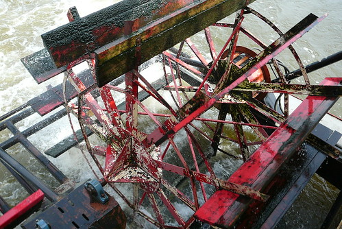
(L) Mississippi River overlook in Davenport, IA; (R) Riverboat Paddlewheel


So there you have it. Six new, amazing categories just waiting to be created. I think the two coastal highways should be first. Any takers?
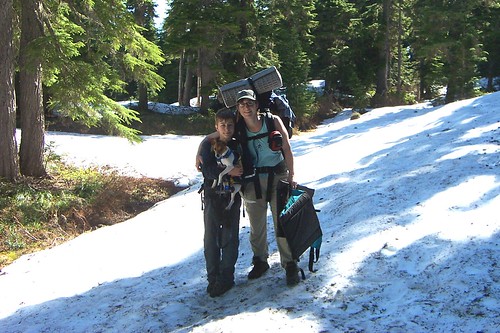
Thursday, April 10, 2008

Category Dictatorships

It has always been a pet peeve of mine when category creators view a category as something "owned" by them. These category dictators see group officers as people to share the work load, but nothing else. In their opinion, they thought up the initial idea and could care less what anyone else's opinion is. I don't see it that way. They are leaders, not owners, and by refusing to listen to officer's suggestions they limit the category.

Close-mindedness leads to categories that become stagnant. If there needs to be some tweaking of the category it helps to have open communication, as I talked about in my last post. Without this communication and tweaking to waymarkers become frustrated and don't continue to submit to the category. Unless I am extremely interested in a subject I won't submit more than one waymark to a category that is unclear as to what type of waymarks they're looking for, or to a category where the officers are rude when they make comments. There are plenty of other categories out there to take up my time. I kick it to my ignore list and move on.

Another issue I have come across as an officer is when leaders go through and re-evaluate waymarks that have already been approved. Nothing is more irritating as a waymarker than to have a waymark approved and then denied. If an officer is regularly approving things that the leader doesn't think fit, then the leader isn't doing their job very well. It indicates that either the category needs to have a few changes or the group needs to sit back and discuss reviewing practices and what is and isn't acceptable. Just re-evaluating an officer's approved waymarks and not politely discussing the problems is micro-managing. It treats the symptoms and not the main issue.

I'm not saying that the leader's vision for the category means nothing, I'm saying it doesn't mean everything. We all share the Waymarking Website and a single person cannot own one section of it. A category is created to share places with the world and a leader is only the category's guide, not its god.

This has been your latest installment of Janell's Pet Peeves. For more, just ask me about chain store categories. (kidding :) The photo above really has nothing to do with this post. The Victorian triplex is posted in the "NRHP - Contributing Buildings" category which is led by a person I've found to be a great collaborative leader, JimmyEv. So I guess that it has a tiny bit of context.

Monday, April 7, 2008

Great groups have great communication

Something that I've noticed lately: the better the communication, the better the category. When a category is approved and the officers start reviewing waymarks they soon find that maybe the category definition or requirements aren't as clear as they expected they would be. That's okay, because if a leader and the officers are doing their job they will talk about issues that are raised and adjust things accordingly. No category is perfect and even the most well written and thought out descriptions might need some tweaking over time.

Discussion, disagreement, even debate, is necessary - in some categories more than others. Next time, before you hit that "vote" button when reviewing a questionable waymark, consider sending out a group email and asking the group about it first. Often there are underlying reasons that things are going to vote - something unclear in the category description that could be fixed. Why not talk it over and see if there's a way to make things clearer. It will save you work in the long run by limiting the posting of waymarks that don't fit the category. It will definitely make people who post to your category happier, because no one likes to put the work into posting a waymark and then have it declined.

If officers in the group don't have the "email group member" ability then be sure to email the group leader and see if they will change this. If you are the group leader, then what are you waiting for?! Go make the changes so your officers can better participate in discussions. I assure you that your category will benefit from the change. There really isn't a reason not to do this. In fact, I wish that it was an automatic feature for officers. Maybe make it automatic, but allow the leader to take back the privilege if an officer is abusing it.

Anyhow, just my 2 cents. Happy waymarking!

Tuesday, April 1, 2008

How small is too small?

Recently I was voting in peer review for something and at the time thought that the available waymarks might be too small in number for the category to be viable. So how small is too small? I can't remember the exact voting criteria, but I know that one of them is "abundance". I've always thought that could go either way - there are so many possible waymarks that there's really no reason to waymark them (my beef with most fast food categories) OR there are so few that they will be too difficult for people to find.
When I think about it though, if something is interesting with maybe a bit of historic importance thrown in, doesn't that make it exactly the type of place to be waymarked so others can find the spot in the future? If there are only 50 possible spots worldwide, wouldn't it be great to create a place where interested folks could find all 50?

Here's another thought. What if the 50 spots aren't worldwide, but they are all in one small area? Would it meet criteria then?

There really is no exact answer. Drawing the line somewhere would be foolish because there are too many factors involved. This is yet another example where being too rigid will limit the Waymarking Website. Better to embrace the fuzziness of the criteria in this case than to create some silly line in the sand.

So here's a confession though. When voting, I admit that my willingness to vote "yea" for a category is definitely affected by how interesting the category is to me. Try as I might to be objective, there are times when I just can't swallow a category and I might invoke the "too many/too few" criteria. I try not to do that very often, but sometimes it happens and I know I'm not the only one who does this so don't get all "holier-than-thou" on me. I'm not saying it's good practice, just that it happens.

Just thinking as I type here, so sorry if this post is difficult to follow. If you do understand what I'm talking about, let's hear how you feel. Oh, and the photo above is 8Nuts MotherGoose's photo of the Dubuque Shot Tower which we visited last summer. "Shot Towers" is one of those categories were the total possible waymarks are very limited, however, it still seems like a worthwhile category.