So, I just finished reading the chat log from Waymarking.com's first "town hall" meeting that took place a couple days ago. The whole time I was reading it I kept wanting to jump in and add my opinion and then would remember it was over. :) Wow! What a great tool for brainstorming about ways to improve the game.
For those of you who don't frequent the waymarking forums and missed out on the chat announcement, there was a live chat meeting this week to discuss the Website and also some new ideas of future upgrades, etc. The plan right now is that these live chat sessions will take place every two weeks or so, and each session would have a specific topic that would be focused on. It's a great opportunity to share your opinion with the folks at Groundspeak who are shaping the future of the game.
My only worry has to do with the fact that I am a technological moron. I have never in my life participated in a live chat session and will first have to set up the software etc. on my computer. On the off chance that I am able to muddle through this (or that my computer savvy sister comes up from Portland, Oregon before the next chat session) I will definitely be joining in the next chat. (I can't believe that I missed an opportunity to complain about GPS photo requirements!)
Friday, August 31, 2007
Monday, August 27, 2007
Waymarking Flickr Fun
 As many of you know there's a Waymarking group on Flickr.com that's devoted to featuring waymarkers' photographs of their waymarks. The waymarker, Ambrosia, started the group and I moderate it with her. We are a pretty laid back group and don't really have the typical Flickr group list of rules. There is no photo limit - all we ask is that the photos are from waymarks that the user has posted or visited on Waymarking.com, and that you add the tag "waymarking" to the photo. Currently there's a thread going in the group about ways to add some fun and I wanted to post a few of the ideas we've come up with.
What I'm most excited about is the scavenger hunt idea that we're working on (the group is still working on the idea, so what I'm describing here isn't set in stone.) On the first of each month a thread would be started that announced the theme of the contest and then a list of 5 (maybe 10) categories that the members would need to find and waymark (waymark must be posted within the month of the contest.) Members would then post their best photo from each of the waymarks they posted and the photos would need to also fit the month's theme. At the end of the month the group would then vote on a favorite photo from each of the categories, and the thread would be closed with a list of the winning photographs and also the first person who was able to post a waymark in each category.
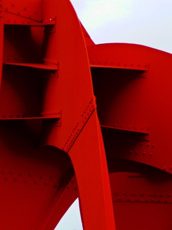
Themes might be seasonal (holidays seasons, weather, etc.,) or visual (vertical lines, curves, etc.) or even something else wild and wacky that I come up with. The challenge would then be to find something in the listed waymarking categories that also has a tie-in to the theme. The theme might be something totally unrelated to waymarking, for example - the color red. If one of the categories in the "red" month's contest was Abstract Public Sculpture I could post the above photo of my waymark for the very red "Eagle" sculpture by Alexander Calder in Seattle, Washington (assuming that it was a new waymark for me.)
Another idea for the Flickr group that isn't as fun, but will market Waymarking is "comment promotion." As a way to promote waymarking, we want to come up with a small block of html that people could copy & paste to the end of their comments about waymarking photos that would have a one sentence description of waymarking and links to the Flickr group and to Waymarking.com. How this works is that often one photo might be in the gallery of several different groups. Right now if the photo's description tells what category the location is waymarked in the people in those other groups might not know what that means. This way people who came across the photo in other groups - say the Flickr scavenger hunting groups - they could learn a bit about waymarking.
If you have more ideas for the group or are interested in joining you can use the group link or thread link above. Currently we have 24 members and close to 200 waymarking photos. We'd love to have you join us.
Thursday, August 23, 2007
Kiss Hunting
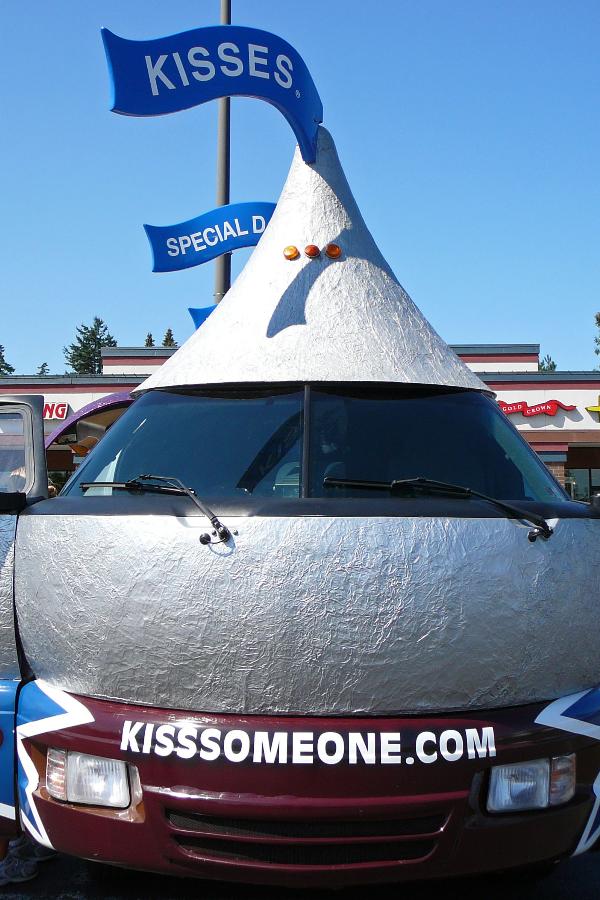 I've been wanting to post a waymark in the Kissmobile Sitings category so about 6 months ago I checked the Kissmobile Website and discovered that it was going to be in the Seattle-Tacoma area in August. The problem is that although they are great about keeping a schedule on their Website, they only tell you when they will be in a region, but not where in the region they will be stopping. The Seattle-Tacoma metropolitan area is a pretty large place for a Kissmobile (K.M.) to hide. It just wasn't worth the hassle so I gave up.
Then last week I spotted the Kissmobile on I-5 driving home from Seattle. I was tempted to turn around and follow the thing, but I was with a non-waymarking friend and I didn't think she would get it if I yelled "tail those giant Hershey Kisses!" I restrained myself, but it reignited my compulsion to post a waymark in this category. I did one last web search to see if anyone in the area had listed that the K.M. was showing up at their store or event. SUCCESS! In just 2 days time, their last stop before heading to Eastern Washington, they would be in a town about 20 miles from our home.
So today we drove out and at noon, just as they were setting up we took our pictures - 2 fun pics and the required pic with a waymarker and gps in it as well as a required pic of the license plate. It was fun to grab the waymark, and the new "Kissables" candies they were handing out were pretty good - think m & m (Smarties for those of you up in Canada) meets Hershey's Kiss.
Our Kissmobile waymark hasn't been approved yet so it might not be visible yet. Hopefully soon though.
Monday, August 20, 2007
A Weekend in the Hills
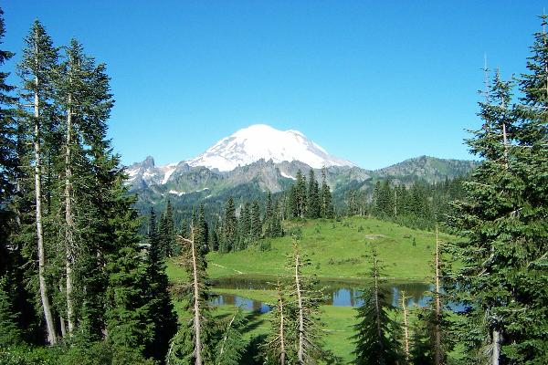
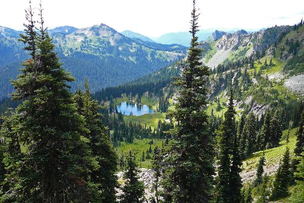 I've been busy posting the 20 or so waymarks that I found while camping and hiking on Chinook Pass near Mt. Rainier National Park. Early Saturday we started a hike up to Sheep Lake and Sourdough Gap along the Pacific Crest Trail. For those of you who aren't familiar with the trail, it is a 2,600 mile trail that runs from the Canadian to the Mexican border through some of the most beautiful spots in the country. The wildflowers were gorgeous and the view from the gap was amazing. We continued past the gap into Mt. Rainier National Park, but didn't feel up to continuing to the next 2 gaps along the trail. It was freezing cold, but at least the area wasn't fogged in. There are some camp sites at Sheep Lake (seen in the picture above) and I think we might backpack in next year and use the lake as a base camp for further hikes. I waymarked the hike and surrounding area in many categories, including Named Mountain Gaps, Scenic Hikes and Hiking Footbridges.
After the hike we drove over to the Sunrise area of Mt. Rainier National Park. In my opinion this section of the park has the best views of any of the major visitor centers. Paradise is great for wildflowers, but if you want vistas of Rainier and limitless amazing hikes, head to Sunrise. Here we found many more waymarks, including one for the elusive Ansel Adams Photo Hunt category. Others were Scenic Overlooks, NRHP (still to be waymarked), National Parks of the World, and another Glacier waymark. The Ansel Adams waymark was one that I've been wanting to go and waymark since last winter. Unfortunately the weather wasn't cooperating so you can only see the lower half of the mountain, but there was enough of Emmons Glacier showing to see that it was the same area. I only know of 2 landscape photos that Adams took in Washington State, so I was glad to be able to grab this one.
Some of the above waymarks haven't been approved at the time that I am posting this so they may not be visible on the site yet. We were able to post waymarks in 6 new categories this weekend. A big disappointment was that the two Smokey the Bear signs had been removed and instead there was just a small painted smokey on one of the fire risk signs, so no Smokey waymark for us.
Unfortunately the weekend ended on a wet note. It rained steadily all night and we discovered that our REI backpacking tent leaks! Our Kelty family camping tent was put through a tough test of a full night of pounding rain in the Midwest and not a drop came into the tent. Now, our supposedly superior backpacking tent leaked not just from near the base, but overhead and I ended up suffering the equivalent to Chinese water torture as it dripped icy water on my forehead for half of the night. And this was Washington rain! A slow drizzle, not the pounding stuff we dealt with in Iowa. Time to break out the seam sealer, I guess. We broke camp at 6 a.m. and headed home, only stopping to waymark a VFW hall and a church steeple on the way home.
Friday, August 17, 2007
Heading to the Hills
 The road trip threw our usual camping/hiking routine out of whack this summer - typically we try to head into the mountains every other weekend starting in early May, and sometimes even March or April if we have a dry weekend. It's some of my favorite waymarking territory and definitely the place that revives me after a grey winter in the 'burbs.
This weekend we'll finally be heading up into the Cascades for a trip and I'm very excited. The plan is to camp at a Federal campground near Mt. Rainier National Park and then to drive to the top of Chinook Pass to do some hiking on the Pacific Crest Trail. It's the only trail in the National Park that you can take dogs on, so we didn't have many choices of where to go, but it's wildflower season and the sub-alpine meadows should be sublime right now. The crest of Chinook Pass is one of my favorite spots in the Cascade Mountains, full of wildlife, wildflowers and wild landscapes. I waymarked the pass in the American Guide categories and it was one of my favorite waymarks to put together because I have so many memories up there.
I'm hoping to pick up a few categories this weekend - Smokey the Bear, Named Mountain Gaps (we're hiking up to Sourdough Gap), and a few more. I might even have a chance at an Ansel Adams Hunt waymark, but it depends on the weather. It will be refreshing to list a few waymarks in Washington again. I'm still slogging through all of the vacation waymarks from the Midwest.
The photo above is of Tipsoo Lake with Mt. Rainier in the background. The lake is near the top of the Chinook Pass and is a beautiful spot for a day trip. Bring a picnic and stroll around the lake. In early August the meadow will be thick with wildflowers. The lake is next to a CCC built comfort station with tables near the parking area. Stay on the trail - this area is very delicate.
Wednesday, August 15, 2007
Waymarking Photos
 It's always a disappointment to me when I have to photograph something for a waymark on a gray day (which happens quite often here in Washington State.) The difference between a sculpture set against gray, versus one set against a brilliant blue sky is amazing - it brings out an energy in the object being photographed, and the colors just pop!
Yesterday I spent the day in Seattle visiting the new wing of the Seattle Art Museum and taking a friend to see the Olympic Sculpture Park for the first time. Last time I was at the park it was pretty gray but this day was a day for taking photos. I took pictures of EVERYTHING! The colored glass "shadows" on a gravel path, a vandalized pane of glass in the "Seattle Cloud Cover" piece, every possible shot of the Calder sculpture with the Puget Sound in the background... When I started taking pictures of the gravel path my friend wandered off to make sure people didn't realize she was with me. ;) The shots turned out great though and now I need to get around to adding them to the galleries of all the different sculptures that I have waymarked in the park.
Oh - little photography tip for those taking photos of landscapes. Divide the image you see in your lense into 3 rows both horizontally and vertically. Never have the horizon line, or main horizontal line of the shot running straight through the middle of the picture. Either have it at the imaginary line at the top or bottom third of your shot. Also, if there is a subject that is part of the landscape shot - say a lighthouse on a bluff near the coastline - don't center the subject! Frame it so the subject is on the left or right "1/3" line that you've drawn vertically through your shot. Seems picky, but it will make a world of difference in your landscapes. So often I see waymarking pics come through that would be magazine quality shots if only they had been framed using the "rule of thirds".
The above photo is of the piece "Seattle Cloud Cover" that runs the length of the pedestrian bridge in the park. The light was being cast in all of these wonderful colorful shadows and I must have taken about 30 or more photos of the gravel alone. This shot shows the end of the piece and the shadows that it casts. I liked the perspective of the shot.
Saturday, August 11, 2007
Paperless Waymarking
When you're out waymarking it's nice to have something along to remind you what the requirements are for specific categories. Some of the requirements seems so obscure and it is more than irksome to have something denied because "you MUST have a photograph of the sign showing exactly in the center AND the building showing in the background AND you dancing a jig with your fingers held up making a W for 'Waymarking' AND the gps balanced on top of your head with the time and date stamp showing". Okay, I may be exaggerating a bit but sometimes the requirements are downright silly.
To solve this problem I had been printing out my spreadsheet that lists all of the categories with their requirements coded so they would only take up a single line. Even so I would end up with about 10 pieces of paper that were hopelessly out of date within a month.
The Waymarker, flipflopnick, came up with a great idea that he made available on the forums and on the community tool section of my Website, Wayward Waymarking. He created simple text files of all the category desriptions/requirements and then downloads them to a PDA. It doesn't take up too much space because they're .txt files and they are there at the touch of a button. When new categories are added to the directory, you can just upload the updates. We'll be getting updates from flipflopnick monthly and you can either just download those or make the new text files yourself. No more wasted printouts! If you don't have a PDA and want to go paperless, they can be purchased on Ebay fairly inexpensively - you don't need anything fancy. Of course, this may be a good excuse to buy one of the new ones that do everything but drive the car for you. :)
Wednesday, August 8, 2007
Grid Chat: The latest and greatest on the grid
Did anyone notice that if you click on one of the grid squares that instead of just opening the category's page it opens the category's page with a filter to only show the waymarks you've posted in the category? It's just a simple thing, but very handy, that's for sure.
And yesterday row 28 of the grid was finished off with the new National Trust, UK category. To me this category is a big step. Regionally specific categories are so interesting - they focus on waymarking things that are important to a specific culture and its history. For the hobby to continue to grow worldwide it's important to encourage waymarkers in countries outside of North America to create a few of their own regional categories that speak to the people of their country/region. So a hearty thanks to Brentorboxer and her team of officers.
Lastly, a few new icons I've chuckled over on the grid. The used video game store icon now has an NES controller perched above the storefront - go Nintendo! The Independent Diners icon is near and dear to my chain restaurant hating heart. It's a knife and fork with the word "chain" above it crossed out in red. Heh-heh-heh. :) And as a dog lover how can I not just love the Self-serve Pet Wash category's icon? A dog all sudsed up. Just plain cool icons? The new stained glass flower for the Art Deco/Art Nouveau category, and the Sydney Opera House for my 2 Master Architect categories. And one more thing - did any one notice that it looks like the soldiers on the icon for "Battlefields" are doing Tai Chi? It's a slow motion battle, I guess. :)
Sunday, August 5, 2007
Milestones!
 This week team Hikenutty hit 2 great milestones for a waymarker. Thanks to our 2 week road trip and the several hundred waymarks collected along the way we have hit 1,000 waymarks posted this week. The second milestone for us was to waymark 100 waymarks in a single category. We hit 100 this week in the U.S. National Historic Places category.
Now, I know that waymarking isn't just about the numbers, and as many of you know, I've always been a proponent for quality over quantity, but even so - it feels great! :) I'm not a numbers girl and I haven't really been thinking about where my count stood until I was checking out the changes on the profile pages this week. I saw that I was getting close to 1,000 which is not bad, considering my one year waymarking anniversary was in June. Okay, I'm done patting myself on the back now, guys. :)
Still, the biggest charge for me in waymarking is not in how many waymarks I have listed, but in the charge of walking around a corner and being surprised by an extremely cool place/thing just waiting to be waymarked. I look much closer at the world around me and instead of just breezing down the street, I check out the buildings, art and public spaces. That new perspective on the world around me is the most valuable part of the hobby.
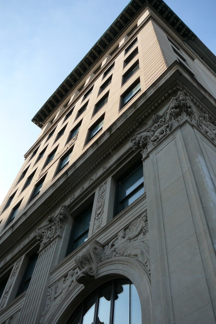
The picture above is of the First National Bank in Davenport, Iowa. It was the first National Bank opened under the National Banking Act of 1863, so it truly is the "first" First National Bank. It was my 100th waymark in the U.S. National Register of Historic Places category. My 1000th accepted waymark was a beautiful wave shaped sculpture made of driftwood at the Figge Art Museum, also in Davenport, Iowa.
Wednesday, August 1, 2007
Profile Page Updates
The team at Groundspeak has yet again added some goodies to the profile sections of the Website that will make the game even more addictive for those of you who love watching your number of waymarks posted and visited slowly (or quickly in some folks case) rise.
On the forums awhile back folks were talking about wanting some kind of award icon added to users' profile pages to let folks know what level they've reached in their total waymarks. Yeah, I know. There's already the little red and white box showing the count, but isn't it fun to get ribbons? A little like the gold stars you earned on school work back in elementary school. The awards start at 25 waymarks and go all the way up to 5,000.
There are other treats, too. On the right sidebar of your profile page you'll see a new box. In it are some great new site functions that you'll be sure to enjoy. You can now click on the "view gallery" link in this box to see all the photos that you've posted to Waymarking.com - your own personal Waymarking photography gallery. If you have Google Earth on your computer you can click on the "Waymarking Footprint" link to see the areas you've waymarked around the world highlighted on the globe. Another Google Earth feature is that you can now click on "Download all My Waymarks" to download your waymarks in .kml format to Google Earth in one fail swoop, rather than page by page, like you used to have to do.
There are probably additional upgrades that I haven't noticed yet, so if you guys see anything that I missed be sure to add it in the comment section of this post.
OH! I almost forgot! The Geocaching.com and Waymarking.com profiles have now been separated so you can personalize each profile to its own Website. Don't panic when you click on your profile page and much of the previous info that you entered is missing. Just go over to geocaching.com and copy the old parts you want to use from your geocaching profile over to your waymarking profile. Here's our new Waymarking specific profile. I love that this has been separated.
Not to be ungrateful, because I LOVE the new profile page set up, but I had one more suggestion for the U.S. map section of the profiles. It might be cool to have a key to the map along the side that shows the different shades of blue and what they stand for (i.e. "1-10 waymarks" and a small box with the lightest blue in it). Just a little extra something, in case you're bored and looking for things to do over there at Groundspeak now that this update is up and running. :)
Seriously, thanks to everyone over at Groundspeak for constantly continuing to upgrade the Website making it more user friendly and just all around a fun place to hang out on the Internet.
Subscribe to:
Posts (Atom)